A Map of New-England, Being the First That Ever Was Here Cut, and Done by the Best Pattern That Could Be Had, Which Being in Some Places Defective, It Made the Other Less Exact ; yet Doth It Sufficiently Shew the Scituation of the Countrey, and Conveniently Well the Distance of Places
Item
-
Title
-
A Map of New-England, Being the First That Ever Was Here Cut, and Done by the Best Pattern That Could Be Had, Which Being in Some Places Defective, It Made the Other Less Exact ; yet Doth It Sufficiently Shew the Scituation of the Countrey, and Conveniently Well the Distance of Places
-
Description
-
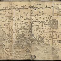
From Leventhal: This map was the first to be printed in the British Colonies, and though crude in appearance was for its time the best available map of the region. Based on a 1665 survey by Bostonian William Reed, it was repurposed by Foster to illustrate William Hubbard’s Narrative of the Troubles with the Indians in New England. The Narrative described King Philip’s War of 1675-76, a horrific conflict between New England colonists and Algonquin Indians. By war’s end the native population had been decimated and dozens of colonial towns (shown numbered on this map) ravaged.
-
Ruler
-
Weetamoo
-
Continent
-
Americas
-
Date
-
1677
-
Century
-
17th century
-
Decade
-
1670s
-
Creator
-
John Foster
-
Type
-
Map
-
short title
-
A Map of New-England
-
Repository
-
Norman B. Leventhal Map Center Collection
-
Boston Public Library